The Folded Rectangle: A Rossendale Paper-Map Drill for Dead Zones
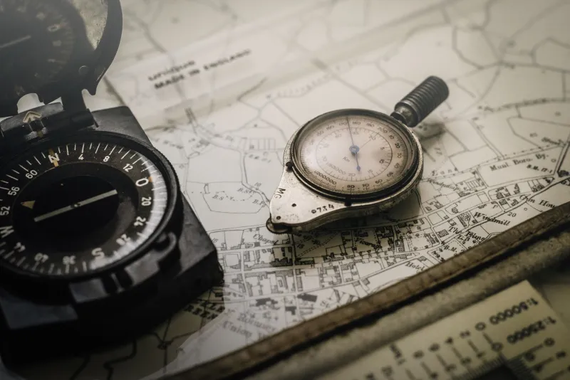
There is a particular bit of the valley where the sat-nav gives up. One minute you have a blue dot and a cheerful ETA; the next you have a spinning wheel, a drained battery and a passenger pretending they knew the turn anyway. It is not a disaster. It is just Rossendale being Rossendale. The answer is not a bigger phone mount or a heroic faith in downloaded maps. The answer is a folded rectangle of paper, a pencil and ten minutes of practice before the next lane day.
Why the hollows eat your signal
Green laning around Rossendale is a game of edges. You drop off the moors into Clough Head or Irwell Vale, you tuck under trees near Waterfoot, you follow a wall down towards a stream, and the phone loses its grip on the mast. Sometimes it comes back at the next gate. Sometimes it does not come back until you are halfway to Bacup and wondering why the app is still showing the last junction.
That is why a paper map is not nostalgia. It is redundancy. It does not need a charge, it does not care about trees, and it shows the shape of the land rather than a single blue line. When the bars go quiet, the map still tells you where the track bends, where the gates sit and which side of the valley you are on.
The map that earns its glovebox space
For most Rossendale lane days, an Ordnance Survey Explorer sheet is the useful one. OL21 South Pennines covers the ground well, and Landranger 103 is a decent back-up for seeing the bigger picture. Buy the paper version, not a printout that turns into a soggy napkin. A map case or a laminating pouch is worth the few quid. So is a soft pencil and a stub of eraser.
Fold the map so the active section is on show, not the whole county. Mark the start and finish. Mark the obvious bail-outs. Mark gates, bridges and any junction where a wrong turn would cost you twenty minutes of reversing. Do not cover the track with a fat highlighter. A light pencil circle is enough. The map should still be readable when the plan changes, because it will.
Build a route card that fits the glovebox
A route card is not paperwork for the sake of it. It is a small, tough note that lets the passenger navigate while the driver drives. Keep it to one side of A6. On the front, write the date, the convoy names, the start grid reference, the finish grid reference, the estimated distance and a rough finish time. Add the radio channel, a bail-out grid reference and an emergency contact who is not in the convoy.
On the back, list the gates and the hazards. Not every gate needs a paragraph. A simple note like gate, west side, latch on left, close behind is enough. Add steep drop on right after bridge or rutted section, walk it first if that is what the lane is doing. The point is to give the passenger something to call out and the driver something to check against. It also means you are not relying on memory after a long, muddy morning.
Grid references without the panic
Grid references look officious until you use them twice. Read them left to right, then bottom to top. Along the corridor, up the stairs. A four-figure reference puts you in a square; a six-figure reference puts you at a gate. For lane days, four figures are fine for a car park or a village, and six figures are better for a gate or a tricky junction.
Write the references down before you leave. Do not trust yourself to read them off a folded map while wearing muddy gloves at a junction. The passenger should be able to find the start, read the first gate reference and point to the next obvious handrail: a wall, a stream, a line of trees, a pylon. If the map says the track follows a wall on the left for half a kilometre, that is more useful than a route arrow that says continue.
The car-park drill
Do this before the engine is warm. Park up somewhere sensible, hand the map to your passenger and give them the route card. Ask them to find the start and read the grid reference aloud. Then ask them to find three things: the first gate, the first bail-out and one feature you will see if you have gone too far. Give them two minutes. No pressure, no sighing, no taking the map back.
Next, you drive a short, easy stretch. The passenger gives instructions in plain language. Not south-south-east, but follow the wall, gate in 200 metres, grid reference on the card. You repeat the instruction back. If it is wrong, stop somewhere safe and sort it out together. The drill is not a test. It is a way of finding out where the gaps are before the lane gets narrow and the light starts going.
Gates are navigation anchors
On Rossendale lanes, gates are the punctuation. They tell you where you are, how far you have come and whether you are still on the right track. Note which side the hinge is on, whether the latch is stiff, and whether the gate needs closing. A gate that opens onto a yard or a field is a different proposition from a gate on a through track. The map will not tell you everything, so write down what you find and share it with the next crew.
Use handrails as well. A wall running along the left, a stream down the right, a line of pines on a ridge: these are the things that keep you honest when the track splits and the blue dot is still sulking. Pick a catching feature too, something obvious that tells you to stop and reassess if you reach it. A road junction, a farm building, a bridge over the Irwell. If you hit the catching feature early, you have gone wrong.
When it goes quiet, stop
If the signal dies and the map is not making sense, stop in a safe place. Do not drive on hoping for a bar or a familiar corner. Get the map out, find the last grid reference you are certain of, and work forward from there. If the convoy is split, say so on the radio. If you are solo, tell someone where you are and what you are doing. The brave move is not pressing on. The brave move is being the person who says I am not sure, let us check.
A paper-map drill is not about becoming a cartographer. It is about keeping the day moving when the technology taps out. Ten minutes in a car park, a route card in the glovebox and a passenger who knows how to read a grid reference will do more for your Rossendale lane day than any phone cradle. The map stays folded. The kettle stays in the boot. And when the bars drop to zero, nobody has to pretend they knew the turn anyway.